Case Study: How a Custom Software Flood Assessment Tool Helps Prioritize Future Analysis
Since 2015, more than 100 people have died annually in the U.S. because of floods—an overwhelming majority of those in Texas.
Floods can’t be prevented entirely.
That being said, flood risk can be identified, and mitigation measures can be established to reduce flood risk and consequences, thereby improving public safety, supporting economic viability and providing environmental stewardship.
Therein lies the premise of this case study—to show how partnership and innovation were used to create a solution to identify areas in need of further flood risk identification and assessment.
Background
Flood management is a shared responsibility among local, state and federal partnerships. The Federal Emergency Management Agency (FEMA) has been implementing the Risk Mapping, Assessment and Planning (Risk MAP) program across the nation in recent years. The Texas Water Development Board (TWDB), in partnership with FEMA through the Risk MAP process, initiated a Technical Pilot Project to gather readily available data to identify watersheds with the greatest risk and need for Risk MAP products. It was the TWDB’s first step in formulating a statewide plan.
Through the Technical Pilot Project, the TWDB wanted to identify Hydrologic Unit Code (HUC)-8 watersheds to be funded for further flood risk identification and assessment. The purpose of this activity was to identify the feasibility and applicability of preparing a statewide prioritization to better identify and recommend FEMA Cooperating Technical Partners (CTP) projects for future years.
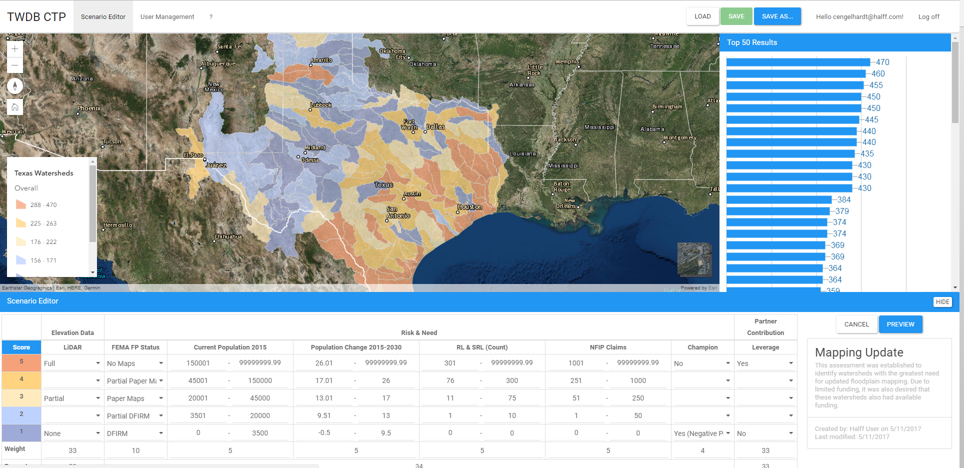
The Technical Pilot Project produced a prioritization website, which allows approved users to rank watersheds—in terms of risk and need—using adjustable weighted factors.
Approach
The TWDB contracted Halff Associates to advance the assessments using current statewide datasets and to develop a flexible statewide prioritization tool that could be used right away—and easily modified—to fit the state’s future needs.
The database compiled for this project included the best available statewide datasets typically collected in FEMA’s “Discovery” process to identify, locate and evaluate study needs and flood risk throughout Texas. From the database, the TWDB selected the following criteria for use in the prioritization assessment: elevation data (available LiDAR); risk and need (population, population change, repetitive loss properties, national flood insurance policy claims, watershed champion and mapping status); and partner contribution (available leverage).
Weighted factors were assembled next for all assessment criteria; as some criteria were better indicators of risk and need, they were assigned a higher weight. All HUC-8 watersheds in Texas were included in the assessment process.
Challenges
Many HUC-8 watersheds in Texas desperately need improved flood risk information and mapping to better define risk and potential mitigation solutions. FEMA and the TWDB are challenged by the lack of available funding to prepare studies, define flood risk and update flood insurance rate maps (FIRMs).
Due to the limited available funding for Risk MAP projects, this Technical Pilot Project was initiated to develop an unbiased evaluation and prioritization of Texas HUC-8 watersheds. The project included coordination with multiple federal and state agencies to collect and inventory available data pertinent to defining flood risk.
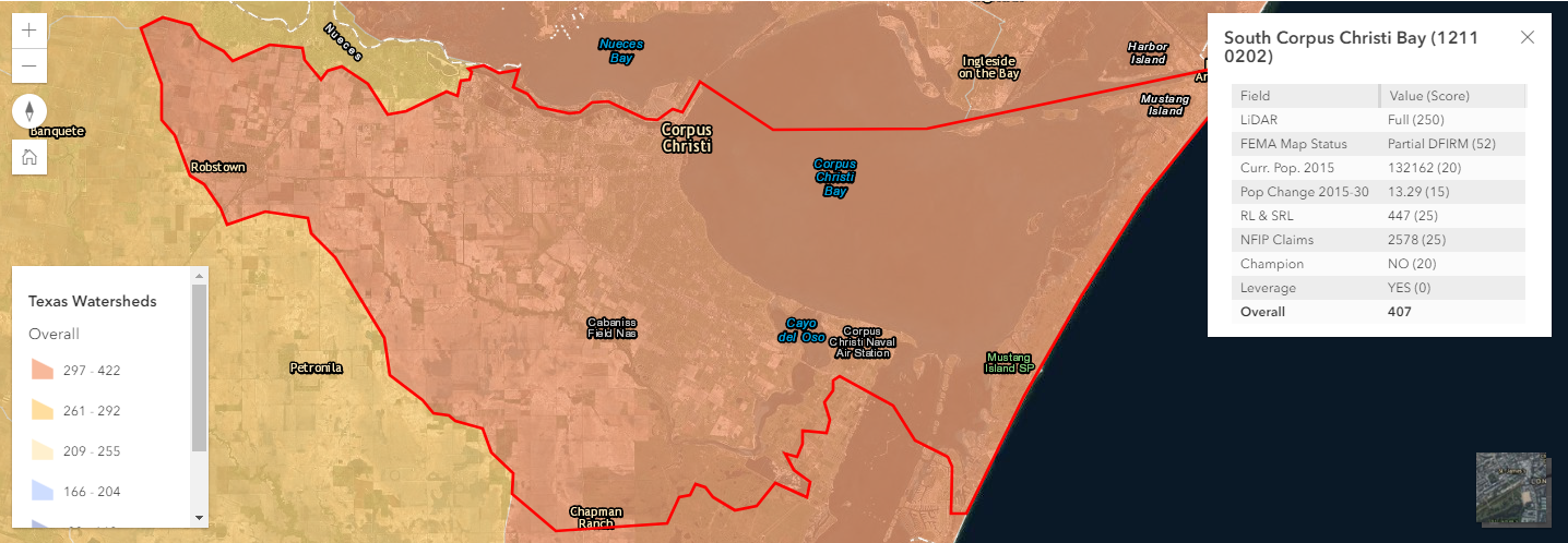
Users of the scenario web application can view watersheds and key information about them.
Results and Benefits
The assessment tool began as a GIS/spreadsheet-driven product. However, the Halff Software Development team developed an interactive scenario web application, allowing users to simulate and evaluate different watershed analyses based on the variable weight inputs. Assessment results can be saved and compared efficiently.
Overall, the TWDB Technical Pilot Project generated an effective tool to view and analyze flood risk, flood hazards, flooding history and floodplain management activities. The results of these analyses will assist the TWDB, FEMA and communities in identifying areas that need further flood risk identification and assessment.
The effort produced a comprehensive, cost-effective assessment tool to objectively direct where future funds should be spent. The prioritization tool and its results will become even more refined as emerging data becomes available over time.
The TWDB Technical Pilot Project will also serve as a vehicle to integrate and synchronize diverse flood risk management projects and programs of the U.S. Army Corps of Engineers (USACE), FEMA and TWDB, as well as regional and local governments. The project also includes the evaluation of future suggested maintenance and potential enhancements that can be conducted as the programs evolve. As federal and state programs shift focus, the tool can be modified to align with new priorities.
The project received a gold medal in the Surveying and Mapping category of the 2018 ACEC Texas Engineering Excellence Awards.
For more information about how Halff’s Water Resources can create custom solutions for you, write to Info-Water@Halff.com.
Recent Stories

Halff Honors Samantha Kaschel with 2026 HCI Outstanding Volunteer Award
Samantha Kaschel (center) was presented with Halff’s HCI Outstanding Volunteer Award by Senior Vice President Leigh Hollis (right) and Deputy…
Transportation Policy is Now Under a Magnifying Glass: Here’s What to Know
The country is facing a shot clock for the reauthorization of surface transportation infrastructure funding. The current federal transportation authorization…