Leveraging AI for the Next Generation of Survey & Geospatial Insights

From astrolabes to artificial intelligence (AI), surveying tools and technologies have come a long way.
The next generation of survey and geospatial services is truly remarkable, as it continues to be transformed by AI’s capabilities. It’s amazing to recognize the strides of progress and future potential.
Read on to discover how AI has (and will continue to) drive a better way to survey!
AI Takes to the Field
The advent of AI has begun to transform industries across the globe, and the fields of survey and geospatial are no exception. The integration of AI and automation in geospatial technology is revolutionizing survey workflows.
Times have changed since the early days of surveying. Technical developments in surveying can be grouped into four distinct phases:
-
-
- Archaic (as early as 1400 B.C. – 1590s)
- Optical (1590 – 1924)
- Electro-Optical (1925 – 1989)
- Multi-Sensor (1990 – present)
-
The most recent (and current) phase, the multi-sensor phase, has rapidly evolved over the last 35 years with the development of the Global Positioning System (GPS) and multi-sensor technology. What were once labor-intensive and manual processes are now highly efficient, data-driven efforts.
These tools and technologies improve efficiency and high-precision data collection.
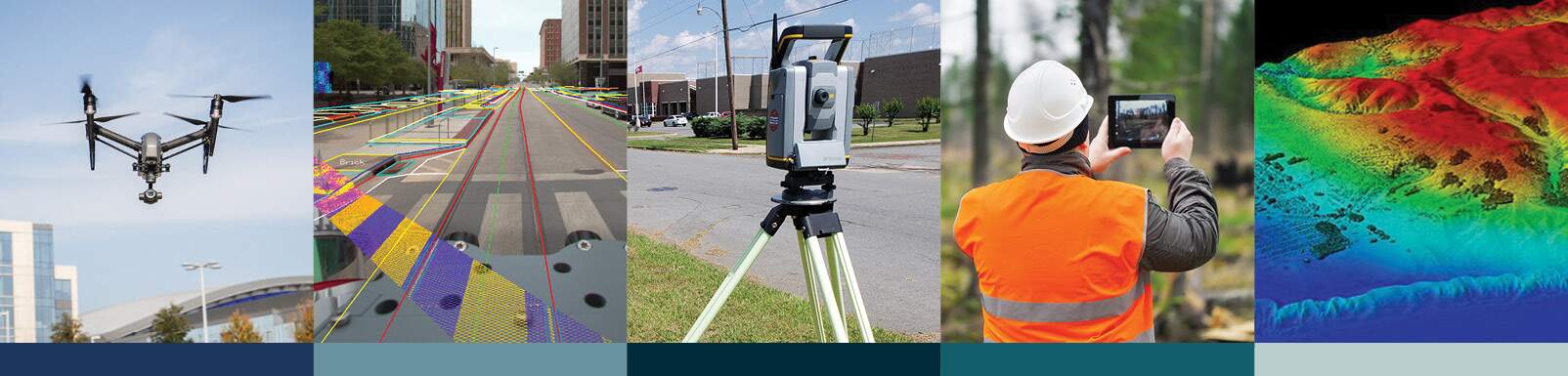
Dubbed “Surveyor 4.0” (Rudolf Staiger, GIM International), today’s technologies consist of lidar, unmanned aerial vehicles (UAVs) and drones, 3D modeling and building information modeling (BIM), advanced software and last but not least, AI and machine learning.
Defining AI
Put simply, AI is technology that automates tasks, makes predictions and generates insights from data and prompts. When applied to the surveying field, the result is impressive to say the least. And its capabilities are continuing to get better.
AI algorithms will continue to learn, gaining sharper ability to analyze large volumes of data from sources like drone imagery, lidar scans and satellite imagery. Traditional surveying instruments, such as the GPS and total stations, are also being complemented by AI-powered systems that improve accuracy and consistency. It can then extract features, identify patterns and generate actionable insights… working as an “AI Surveyor.”
This means hours of manual data processing time will be significantly reduced and streamlined, resulting in increased efficiency and cost savings. This will provide surveyors more time to focus on complex analysis, critical thinking and client engagement—tasks which AI cannot replace.
Challenges and Trends

Accuracy of AI-based analysis heavily relies on high-quality input data.
The use of AI in surveying has made leaps and bounds of progress, but surveyors will be required to exercise caution.
Surveyors today have a professional responsibility to ensure data accuracy and proper use of AI. Surveyors also need to be trained in utilizing AI tools effectively to interpret results. While AI to a certain degree can help enhance surveyor reports and analyze historical survey data, it still needs to be verified for complete accuracy and quality.
From an ethical standpoint, data privacy and security must be carefully managed, and regulations, rules and legal constraints will need to be validated.
There are many functions in which AI in surveying will enhance:
-
-
- Automated data acquisition, real-time processing and data analysis
- Feature extraction and predictive modeling of Digital Terrain Models (DTMs) and Digital Elevation Models (DEMs)
- Asset inventories and geodatabase compliance
- Data augmentation and analysis
- Analysis of aboveground and underground utilities
- Property corner identification by type and size from pictures
- In-depth research of documents and historic records
- Deed sketch generation from legal descriptions and vice versa
- Pairing and cross-quality assurance/quality control (QA/QC) of exhibits and right of way maps to legal descriptions
- Reviewing and analysis of legal precedents affecting boundary determinations
- Ensuring compliance with legal regulations (depending on region)
- Contract reviews and proposals
-
These functions are expected to be part of the surveyor’s daily AI routine as soon as they reach a reliability level of 60-70% and above.
Advanced Applications of AI at Halff: Real-World Impact
Halff remains at the forefront of these industry changes by leveraging and investing in AI-driven solutions on projects today. The result is improved efficiency, accuracy and scalability.
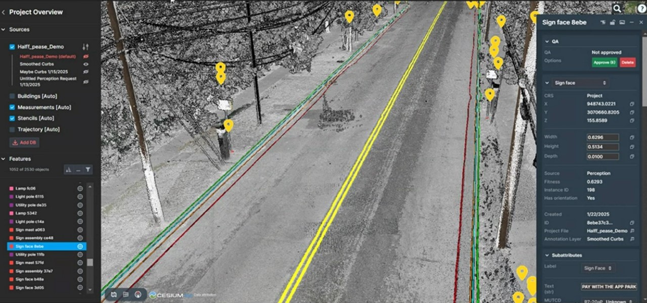
Mobile and aerial lidar scans at Pease Elementary showcase AI-driven surface utility identification.
Pease Elementary School: Halff’s Survey team conducted detailed scans using a blend of mobile and aerial lidar technology for Pease Elementary School in Austin, Texas. The scope of work included boundary, ALTA, tree, topographic and existing conditions surveys. The data, once gathered, was processed and uploaded to a tool with sophisticated AI algorithms that identified and labeled surface utilities on the site (example pictured above).
Additionally, the AI extracted road features from the mobile mapper’s data, including road striping, curbs and edges of pavement. All this enhances surveying precision and efficiency.
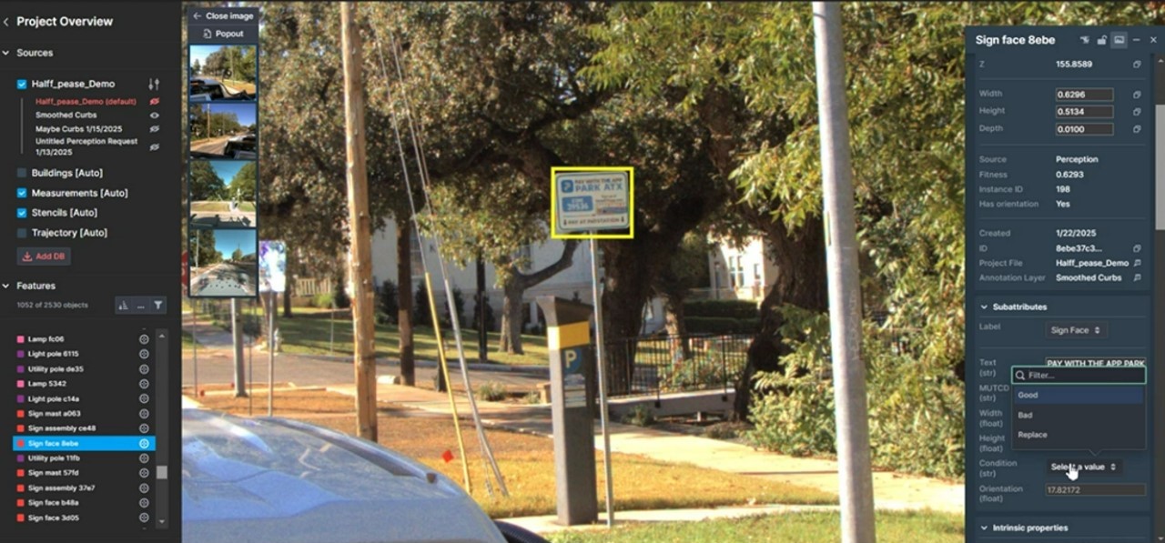
AI is useful for image recognition like this street sign identification, used for GIS database driven asset inventories.
AI-powered image recognition (pictured above) also enables rapid identification of infrastructure and natural landforms.
Real-time data processing, supported by AI and cloud computing, will further accelerate survey workflows, with mobile and aerial mapping systems processing data on the fly. This AI-driven quality control will further detect inconsistencies and anomalies, ensuring precise and reliable survey outputs.
AI-enhanced UAVs will optimize flight paths for comprehensive coverage, while mobile lidar will utilize improved AI algorithms to refine point cloud registration and noise reduction. Machine learning will also be useful for enhancing terrain differentiation. These technologies work together to elevate data accuracy, support floodplain mapping and streamline infrastructure planning in so many ways.
AI Shapes Next-Gen Surveying Solutions
The broader impact of AI lies in reshaping how surveyors work and analyze data. All this is ushering in the next generation of survey and geospatial insights.
“While AI can generate variations based on existing patterns, it cannot conceive truly novel ideas or understand their deeper significance. Innovation requires not just creativity, but also understanding human needs, desires, and the subtle nuances of society – qualities that remain uniquely human.”
– Bernard Marr, Forbes
Roles of the traditional surveyor will continue to evolve, but the essence of surveying—to map boundaries, analyze data and build—remains firmly anchored in human expertise augmented by the power of AI.
Halff is a leading provider of high-quality, innovative surveying and geospatial solutions. Our expertise spans topographic mapping, route surveys, oil and gas surveys, and engineering surveys. Complemented by our thoughtful use of AI, Halff follows a structured approach to survey project execution, coordinating closely with our clients.
Partner with us by contacting Halff today!
Recent Stories

Halff’s RJ Endsley Named ASCE Austin Engineer of the Year
AUSTIN, Texas — Halff’s Central Texas Market Leader RJ Endsley was named the 2026 Engineer of the Year by the…

Gravel Ridge and FSM Aircraft Arresting System Awarded Gold by ACEC Arkansas
LITTLE ROCK, Ark. — Three Halff projects collected 2026 American Council of Engineering Companies (ACEC) Arkansas Engineering Excellence Awards (EEA)….