Why Properly Structured Water Databases Are So Important
One of the hottest topics this year among water experts and managers has not been about water itself.
The topic? Data.
It was deemed so important that Texas’ leading water data stakeholders were invited to Austin in April to participate in a workshop. The driving force behind the gathering was this: Water information is collected around the state for many purposes, and it comes in several different “shapes and sizes.”
But the information isn’t accessible. Platforms aren’t standardized. The data isn’t usable.
Why is that a problem?
It leaves public officials and other important decision-makers guessing, to an extent, as to what is really happening with water supplies or how to handle real-time decisions made about flooding events, water conservation and water reuse.
The goal of the Connecting Texas Water Data Workshop, as one participant group described, was to envision a system that made data “findable, accessible, interoperable and reusable.”
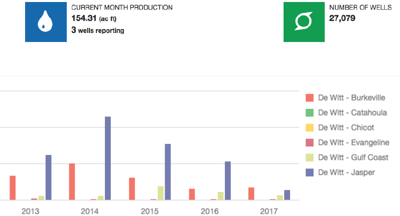
A management dashboard in a water database can show key performance indicators, metrics and data points.
Benefits of Creating a Groundwater Management System
The famous proverb, “Knowledge is power,” certainly applies. Groundwater conservation district databases that are digital, accessible, shareable and useful are essential for the benefit of the district, plus other users such as land owners, water supply companies, consultants, planners, the agriculture industry and other water resources managers.
The benefits are immense—beginning with a task as simple as having the information at hand to respond to public information requests.
The Texas Water Development Board also requires groundwater conservation districts to manage desired future conditions. DFCs are defined by the TWDB as “the desired, quantified condition of groundwater resources (such as water levels, spring flows or volumes) within a management area at one or more specified future times as defined by participating groundwater conservation districts within a groundwater management area as part of the joint planning process.”
In other words, water level measurements taken of an aquifer and other recorded conditions are updated frequently as groundwater conservation districts gauge how they are performing toward their DFC requirements. That information is best kept in a database system that is flexible, has open access and can generate relevant reports quickly.
District boundaries, and even groundwater management areas, are typically drawn along political subdivisions—not aquifer boundaries. This necessitates an easy way to share the information collected for a given aquifer between districts to support updates to groundwater availability models. Having a structured database that identifies monitoring wells used for DFC tracking, along with the methods used to collect water level measurements, provides an efficient way to monitor the DFC over time at the district level and share this data with other stakeholders.
Structure, Organization and ‘Rules of the Road’
There are several questions for groundwater conservation districts to consider when organizing a database.
What information do you want to collect? Databases ought to be structured to include key data about wells, owners, permits, water levels, production and field inspections at a minimum. There may also be built-in relationships, such as those between wells and permits or wells and well owners. The database should also allow for uploading and managing documents and images associated with drilling and permitting applications as well as field inspections.
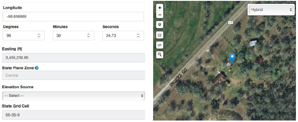
Well location information can be maintained in a central location.
Do you need a map? If so, what should it do? The old adage that a picture says a thousand words—that is what a map of well locations can provide for a groundwater conservation district. Knowing the location of a well, or a proposed well, can assist with spacing requirements, determining the depth of a given water bearing formation or seeing the spatial distribution of monitoring wells.
What information should the public see? Allowing the public to see general information about wells and where they are located can help minimize the number of information requests from the public.
What are your reporting needs? This is instrumental because the design of the database should be in line with how it will be managed and how reports will be pulled from it.
How will the data be accessed? The two most common options for storing groundwater data are either locally within a file-based storage format, e.g., Microsoft Excel or Access, or within a database management system such as Microsoft SQL Server. The file-based option is easy to set up and manage, but is limited to one user at a time and must be used from a desktop or laptop computer. The database management system can be hosted through a web application that allows for multiple users at once and is accessible from any device connected to the internet.
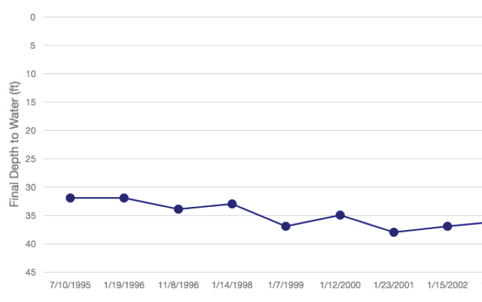
Water depth history can be viewed easily by pulling a report such as this.
Once a database is operational, it is critical to form rules and good habits around data entry. Remember: Reports are only as good as the information entered into the database. If data is incomplete or fields are filled inconsistently, the generated reports won’t be as effective. A database system can help maintain enforcement of district regulations. Good rules to follow include the following:
-
Incorporate a valid range for well location coordinates to ensure wells are within the district.
-
Implement dropdown lists to eliminate typos and erroneous data from populating the database.
-
Calculate values automatically. Examples include acre-feet-to-gallons conversions and expiration dates based on permit terms.
-
Define roles that prevent sensitive data from being seen or changed.
-
Verify that production data is not duplicated.
-
Warn if a new well will be located too close to another well.
Rules often prevent user mistakes; exceptions typically lead to data problems.
Halff Associates’ Groundwater Management System has been implemented by 15 groundwater conservation districts across Texas and customized to meet their needs and management goals. Visit https://gms.halff.com to learn more about the system’s capabilities and sign up for a 60-day free trial.
For more information, write to Info-GIS@halff.com or dCoyer@halff.com.
Recent Stories

Building What Lasts at the Coast: Q&A with Coastal Engineering Lead Kazi Sadid
How is coastal engineering a symphony of engineering design and the natural environment? Where weather, water and environmental systems collide,…

Inside Halff: A Look at April 2026
Halff celebrated a month of recognition as project achievements and employee honors were highlighted across the firm, alongside continued community…